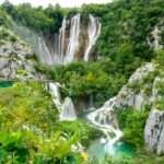
If you are like us and enjoy in crafting every detail of your trip, then let us talk about each lake in this beautiful Plitvice Lakes National Park. In total of sixteen lakes, and more than 90 waterfalls, which are divided by 12 lakes in the area called “Upper Lakes” and 4 lakes in “Lower Lakes”, it covers the area of 73.000 acres.
“PROŠĆANSKO JEZERO” (“Prošćansko lake”)
The highest lake is called “Prošćansko jezero”, and it is the first and the highest lake in Plitvice lakes, located at the altitude of 639 meters. Situated in the first part of the Upper Lakes, it handles its form as an extension of basic substrates dolomite. This lake is also the second largest lake in the whole Plitvice Lakes National Park area. Spread in the total area of 68 hectares, long 2,1 kilometres and width changing between 190 meters and 400 meters. “Prošćansko jezero” got its name after a word “prošće”, which means “sticks” in our language. Due to its geographic position and size, its water has mesmerizing dark green colour. Area around the lake itself is filled with forest, while its leaves are reflecting in the water, so it reflects different colours each season. Water in “Prošćansko jezero” comes from Crna and Bijela streams, coming from the fluent Matica river. As a visitor, you can come along the right side of the lake, because the left bank is protected, as for access is not allowed. When you come at the end of the lake, you will see Labudovac plateau and waterfalls, which fall down into two next lakes.
GPS COORDINATES OF “Prošćansko jezero”: 44.860195,15.600659 / 44°51’36.7″N 15°36’02.4″E
“JEZERO CIGINOVAC” (“Ciginovac lake”)
“Jezero Ciginovac” is commonly known as “Ciginovac” or “Cigino jezero”, and it has the second place on the highness of the lakes in Plitvice lakes area. Its altitude is on 626 meters. This lake is spread in the total area of 7 hectares, with its depth of 11 meters in the middle. As mentioned before, it is also situated in Upper Lakes area. Its name comes from a part “cigan”, which translated into English means “gypsy”. The water canal feeding this lake is also Labudovac, accepting its water from “Prošćansko jezero” and also Delta (natural travertine which borders the lake). You will see this lake at its best point by following the northern shores, which are bordered by “Stubica” hill. Also, there is a viewpoint called “Tomićeva pogledala”). On the opposite side, you will see beautiful, yet thick forests on the border. Here the water also reflects as dark green, but only in the summer, while other parts of the year it reflects the leaves colours and charms. When you come to the end of the lake, you will see a barrier where the water continues to the next lake, called “Okrugljak”.
GPS COORDINATES OF “JEZERO CIGINOVAC”: 44.872871,15.595428 /44°52’22.3″N 15°35’43.5″E
“OKRUGLJAK JEZERO” (“Okrugljak Lake”)
“Okrugljak jezero” is commonly called “Okrugljaj” or “Kruginovac”, and it is the third, highest lake in the whole Plitvice Lakes National Park, coming to the altitude of 613 meters. It is reasonably smaller than the first two lakes, covering only 4 hectares of the area. Its total length is 260 meters, and the water is wide a bit more than 100 meters. “Okrugljak” word comes from a word “okruglo”, which means “rounded edges, smooth” in our language. Same as previous, it is fed by the second lake, “Ciginovac”. Here you will spot the change of lake colours, lighter and greener, also a bit turquoise during summer season. The area is very good connected with wooden paths around the whole lake. The end of the lake, its southern part, is formed as a low barrier where waters flow down into “Veliko jezero”.
GPS COORDINATES FOR “OKRUGLJAK JEZERO”: 44.872746,15.600160 /44°52’21.9″N 15°36’00.6″E